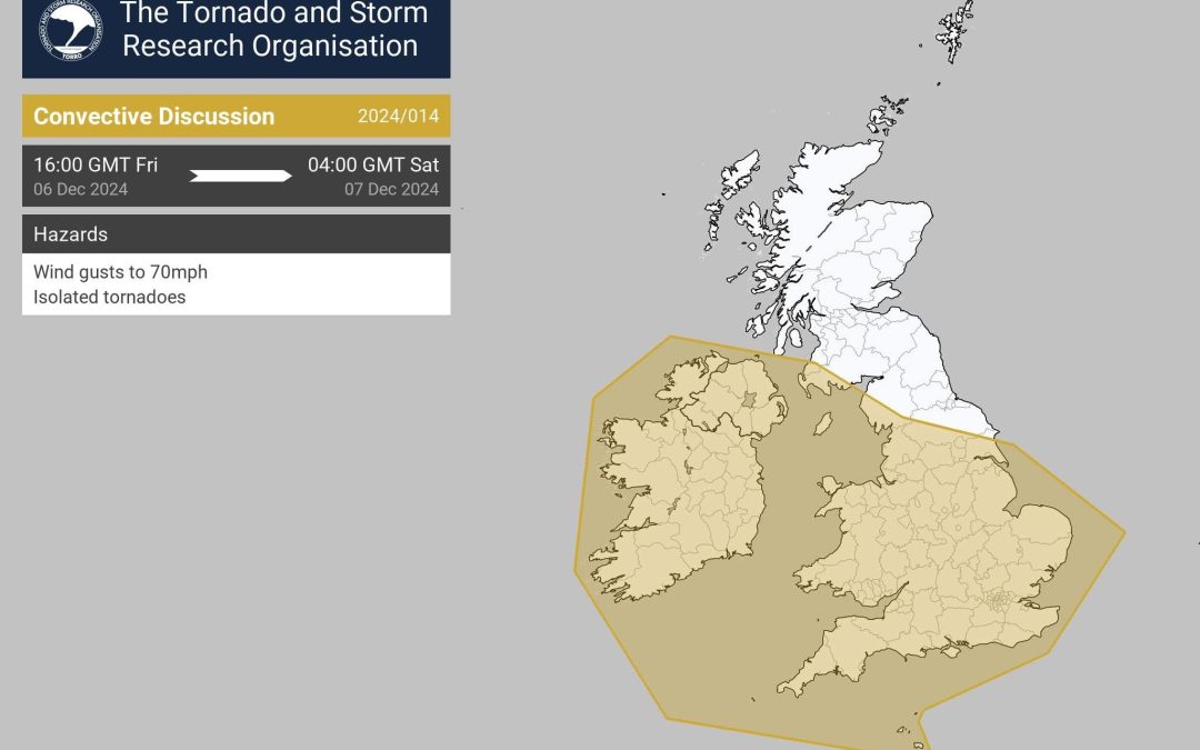
A tornado warning has been issued for Herefordshire.
From TORRO (The Tornado and Storm Research Organisation):
“Storm Darragh will push a frontal system across the area this evening and overnight.
“The cold front will tend to split, with the surface portion lagging behind the upper part.
“This will encourage a shallow moist zone to develop.
“A dry intrusion along should overspread this, especially across the southern half of the indicated area.
“Hi-res models suggest a broken line of shallow convection developing along the surface cold front, which could evolve into shallow supercells.
“Instability is very modest, but the shear through the potential depth of such convection could allow rather strong dynamically-augmented updraughts to evolve.
“Wind gusts to around 70-75mph could accompany the stronger cores, and one or tornadoes are possible too.
“Please note the larger-scale high winds from the storm are covered by the relevant national met service warnings.”
There are a number of road closures in place and flood alerts have been issued, with further rain and strong winds likely to cause disruption across Herefordshire over the coming days.
The C1122 is closed at Wellington due to flooding.
The C1195 Peterchurch is closed due to flooding.
U71205 Boat Lane, Glewstone is closed due to flooding.
Cogwell Brook Lane in Kimbolton is closed due to a landslip.
The road between Madley and Bridge Sollars has flooding in parts.
Further road closures are expected with flooding likely to cause problems across Herefordshire this weekend. Strong winds could also cause additional hazards.
A flood alert is in force on the River Lugg (south of Leominster):
“River levels remain high at the Lugwardine river gauge as a result of recent heavy rainfall.
“Consequently, flooding of roads and farmland continues.
“We expect flooding to affect low lying land and roads adjacent to the River Lugg south of Leominster from Stoke Prior to Mordiford.
“Other locations that may be affected include Bodenham, Lugwardine and Hampton Bishop.”
A flood alert is in force on the River Frome in Herefordshire:
“River levels are forecast to rise at the Yarkhill river gauge as a result of forecast rainfall this evening.
“Consequently, flooding of roads and farmland is possible overnight tonight into the early hours of tomorrow morning.
“We expect flooding to affect low lying land and roads along the River Frome from Bromyard to Hereford.
“Other locations that may be affected include Bishops Frome and Yarkhill.”
A flood alert has been issued on the River Wye in Herefordshire:
“River levels remain high at the Hay-On-Wye river gauge as a result of heavy rainfall.
“Consequently, flooding of roads and farmland is possible today, 06/12/24.
“We expect flooding to affect low lying land and roads along the River Wye from Hay on Wye to Ross on Wye.
LOther locations that may be affected include the A438, Byford, Bredwardine and Hereford.
“Predicted peaks:- Hay on Wye 4.1m to 4.3m Saturday evening, 07/12/24, Bredwardine 5.9m to 6.1m overnight on Saturday 07/12/24, Belmont 5.8m to 6.0m Sunday morning, 08/12/24, Old Wye Bridge 5.0m to 5.2m Sunday morning, 08/12/24, Mordiford 5.0m to 5.2m Sunday morning, 08/12/24.”
A flood alert has been issued on the River Leadon in Herefordshire:
“River levels are rising at the Wedderburn Bridge river gauge as a result of heavy rainfall.
“Consequently, flooding of roads and farmland is possible. We expect flooding to affect low lying land and roads adjacent to the River Leadon. Locations that may be affected include Ledbury, Much Marcle, Staunton and Tibberton. Water may be out of bank at Upleadon Court.”
Further information on flood alerts can be found by visiting – https://check-for-flooding.service.gov.uk/alerts-and-warnings
Storm Darragh will bring periods of heavy rain to south and mid-Wales through Saturday.
20-30 mm of rain will likely fall in 3-6 hours, with totals of 80-90 mm likely by the time rain begins to ease on Saturday evening. Given recent wet weather, coupled with very strong winds from Darragh, impacts on travel and infrastructure are likely.
Warning link – https://weather.metoffice.gov.uk/warnings-and-advice/uk-warnings#?date=2024-12-07&id=8b0f6a38-286a-4908-a63a-05fb2dfef81f


