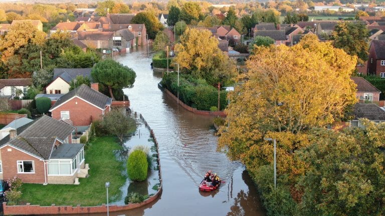
Herefordshire is being warned to be prepared for further flooding, with heavy rain expected today.
The Environment Agency has warned people in Wales and the Midlands to be prepared for flooding as we head towards Christmas. An update on the flood information service page said:
“Ongoing river impacts are probable for the next five days in west central England. Land, roads and some properties could flood and there could be travel disruption. Local flooding is possible but not expected from rivers and surface water in Wales and southern, central and eastern England on Wednesday and Thursday. Properties may flood and there may be travel disruption.”
A number of Flood Alerts are in place on rivers in Herefordshire: (Information from the Environment Agency)
RIVER WYE – Further peaks are possible over the coming days due to further forecast rainfall. Further rainfall is forecast over the next 36 hours. We expect river levels to remain high into the weekend. We are closely monitoring the situation. Please avoid contact with flood water & plan driving routes to avoid low lying roads near rivers, which may be flooded.
RIVER LUGG NORTH OF LEOMINSTER – River levels remain high but steady at the Butts Bridge river gauge as a result of persistent rainfall. Consequently, the risk of flooding remains. We expect flooding to affect low lying land and roads adjacent to the River Lugg north of Leominster. Locations that may be affected include Yarpole, Mortimers Cross, Kingsland and the B4362. Further rainfall is forecast over the next 36 hours which may cause river levels to rise again. We expect river levels to remain high into the weekend. We are closely monitoring the situation. Please avoid using low lying footpaths near local watercourses and plan driving routes to avoid low lying roads near rivers, which may be flooded.
RIVER LUGG SOUTH OF LEOMINSTER – River levels remain high but steady at the Lugwardine river gauge following persistent rainfall. River levels at Ford Bridge remain high but are beginning to fall slowly. Consequently, flooding of roads and farmland is expected to continue. We expect flooding to affect low lying land and roads adjacent to the River Lugg south of Leominster from Stoke Prior to Mordiford. Other locations that may be affected include Bodenham, Lugwardine and Hampton Bishop. Further heavy rainfall is forecast over the next 36 hours. We expect river levels to remain high into the weekend. We are closely monitoring the situation. Please plan driving routes to avoid low lying roads near rivers, which may be flooded.
RIVER ARROW – River levels remain high at the Titley Mill river gauge as a result of persistent rainfall. River levels may drop slightly then rise again. Consequently, the risk of flooding remains. We expect flooding to affect low lying land and roads along the River Arrow from Michaelchurch to Brierley. Other areas that may be affected include Kington, Staunton and Eardisland. Further rainfall is forecast over the next 36 hours. We expect river levels to remain high into the weekend. We are closely monitoring the situation. Please avoid using low lying footpaths near local watercourses and plan driving routes to avoid low lying roads near rivers, which may be flooded.
UPPER TEME – River levels are high but steady at the Leintwardine and Onibury river gauges as a result of recent heavy rainfall. Flooding of roads & farmland is expected to continue. We expect flooding to affect low lying land and roads adjacent to the River Teme, River Onny & River Corve & their tributaries. Locations that may be affected include Bishops Castle, Church Stretton, Knighton & Ludlow. Further heavy rainfall is forecast over the next 36 hours. We expect river levels to remain high into the weekend. We are closely monitoring the situation. Please plan driving routes to avoid low lying roads near rivers, which may be flooded.
LEADON CATCHMENT – River levels remain steady but high at the Wedderburn Bridge river gauge as a result of heavy rainfall. Consequently, flooding of roads and farmland is expected to continue. Flooding may affect low lying land and roads adjacent to the River Leadon. Locations that may be affected include Ledbury, Much Marcle, Staunton and Tibberton. Water may be out of bank at Upleadon Court. Further heavy rainfall is forecast over the next 36 hours and we expect river levels to respond accordingly. We are closely monitoring the situation. Please avoid using low lying footpaths near local watercourses and plan driving routes to avoid low lying roads near rivers, which may be flooded.