
Bloor Homes is preparing an outline planning application for submission to Herefordshire Council for a mixed-use development proposal on Land at Lower Bullingham, to the West of Watery Lane, Hereford.
The proposal forms the first phase of the Hereford ‘Southern Urban Expansion’ site allocation at Lower Bullingham (as per Policy HD6 of the Herefordshire Local Plan – Core Strategy).
This allocation provides for a comprehensively planned sustainable urban expansion which is expected to provide for, among other things, a minimum of 1,000 new homes as well as around 5 hectares of employment land once fully developed.
This emerging planning application for Phase 1 of the allocation will include up to 540 homes and around 5 hectares of employment land as well as a local centre, country park and supporting areas of public open space, with the principal access off the B4399 ‘Rotherwas Relief Road’.
In recognition that Herefordshire Council has identified the site as a suitable location for a sustainable urban extension to Hereford, Bloor Homes is preparing an outline planning application for what would be the first phase of development.
At this stage, it is likely the application will comprise up to 540 homes, approximately 5 hectares of employment land, a local centre, public open space including a country park, together with the necessary supporting infrastructure and associated works.
From Bloor Homes:
The focus of the design and masterplanning approach is to create a clear identity for the site in the way the new homes are designed and arranged in layout; the attractiveness and accessibility of public open spaces; and the creation of distinctive places such as around community facilities, site gateways, the main avenue, and the new employment area. Importantly, the proposal provides the opportunity to deliver a large amount of accessible green infrastructure and public open space within the site for the existing and new local community.
Movement and connectivity through the site are also key design priorities. Our aim is to create a walkable neighbourhood with safe and pedestrian friendly streets.
New footpath and cycle links are proposed leading to employment areas and new parks and onward to other destinations in Hereford City Centre.
As well as engaging with the local community on this proposal, Bloor Homes has been actively engaging in pre-application discussions with Herefordshire Council’s Planning and Highway departments ahead of the submission of a planning application.
Most of the site is currently in arable agricultural use, although there are some existing agricultural/industrial buildings located within the boundary of the site, to west of Watery Lane.
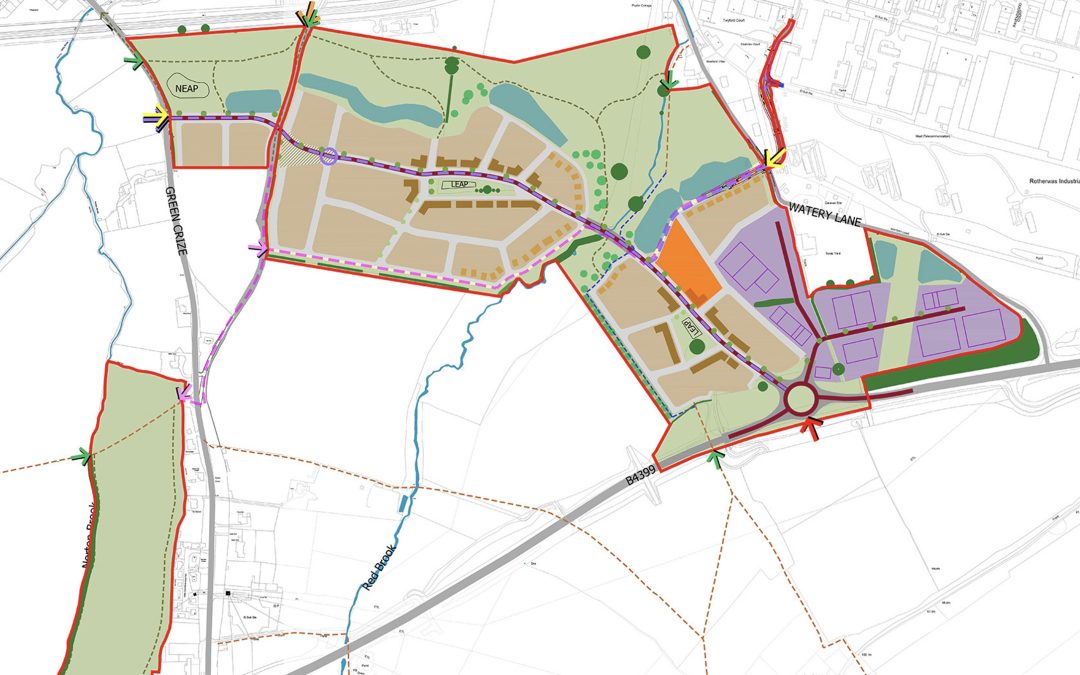
The total site area equates to approximately 104 acres (42 hectares). The site is roughly divided into four land parcels as follows:
The largest land parcel is situated south/west of Watery Lane and the Rotherwas Industrial Estate, and to the north of the B4399 ‘Rotherwas Relief Road’.
The Red Brook runs centrally through the parcel.
To the south there is further agricultural land which forms part of the wider allocated Urban Expansion site.
The ‘red line’ application site boundary also extends from this parcel across Watery Lane to Twyford Road to provide for a new bus / cycle / pedestrian connection to the Rotherwas Industrial Estate.
A further land parcel is situated between Green Crize / Hoarwithy Road and Lower Bullingham Lane; to the west of the largest land parcel contained within the boundary for the proposed development.
This land parcel lies directly south of the railway line which separates this part of the site from the existing built-up area of Lower Bullingham.
An additional area is situated south-west of the largest land parcel, which is proposed as a possible new Country Park.
This land parcel is situated on rising ground to the west of the rear gardens of existing dwellings along Hoarwithy Road and to the east of Norton Brook. The B4399 is situated further south.
Finally, a very small area of land is also included in the red line to the south of the railway line and to the west of Watery Lane to allow a vehicle-by-pass facility on Watery Lane for use by residents along the lane in time of flood.
The key points:
Up to 540 new homes.
Around 5 hectares of employment land located adjacent to the Rotherwas Enterprise Zone.
A Local Centre comprising local retail, community uses and a mobility hub. The mobility hub could include bus stop(s), electric car club, electric vehicle charging, bike hire, delivery lockers and a local information point.
An abundance of public open space including new parkland along the Red Brook, attenuation basins and a corridor of open space over the Rotherwas Ribbon archaeological site within the employment area.
Two local neighbourhood greens that also include Local Equipped Areas for Play.
Neighbourhood Equipped Area for Play in proximity to existing homes and easily accessible by active travel routes.
A Country Park located to the west of Green Crize alongside the Norton Brook. The park could potentially comprise of informal trails, new tree and wildflower meadow planting and seating / picnic areas.
A bus route connecting residential areas to the Rotherwas Enterprise Zone and through the site to Green Crize.
A network of cycle and footways through public open spaces, along retained public rights of way and alongside the main spine street.
Main vehicular access off the B4399 ‘Rotherwas Relief Road’ with a second restricted access to around 100 homes off Green Crize which will only provide a through route to the rest of the site and onward to Rotherwas for buses and emergency vehicles.
To view the website and to have your say, please visit – https://bloorlowerbullingham.co.uk


