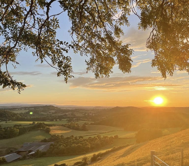
The Met Office is expecting temperatures to peak in the low 30s this week in Herefordshire as England and Wales enters its second heatwave of the summer.
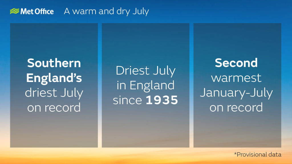
Earlier today, the Met Office confirmed that July was the driest in England since 1935.
The Met Office has since issued a Heatwave Level 3 warning for Herefordshire and other parts of England.
From Met Office:
“There is a 90 % probability of Heat-Health Alert criteria being met between 1200 on Tuesday 09 Aug and 1800 on Saturday 13 Aug in parts of England.
“High pressure dominating this week, with fine and dry conditions across most of the country, prolonged sunny spells and light to moderate breezes. Temperatures rising from warm or very warm to locally hot in most regions, with a focus of the warmest weather in central-southern England. Headline max temperatures reaching mid 30’s by Friday. The biggest question mark is over the end of the hot spell, with recent models indicating thundery showers arriving from as early as Saturday 13th, but perhaps as late as Tuesday 16th. Confidence on this will likely increase later in the week.
“An update will be issued when the alert level changes in any region. Alerts are issued once a day by 0900 if required and are not subject to amendment in between standard issue times. Note that the details of the forecast weather are valid at the time of issue but may change over the period that an alert remains in force. These details will not be updated here unless the alert level also changes, the latest forecast details can be obtained at the following link: http://www.metoffice.gov.uk/public/weather/forecast/#?tab=map“
July 2022 was the driest July for England since 1935, and the driest July on record for East Anglia, southeast and southern England, according to provisional statistics from the Met Office.
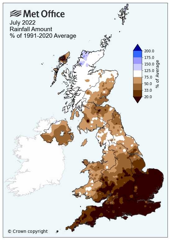
High pressure dominated the UK for much of July, pushing any Atlantic influence, and therefore much of the rain, into the northwest and allowing temperatures to build elsewhere. Overall, the UK saw just 56% (46.3mm) of its average rainfall for July, making it the driest July in over 20 years (with 1999 recording 46.1 mm) and continues a run of all months, bar February, being drier than average in 2022 so far.
Rainfall has not been distributed evenly in July, as is often the case in the UK, though the contrast has been more stark than usual.
England had just 35% (23.1mm) of its average rainfall for the month, Wales 53% (52mm), Northern Ireland 51% (45.8mm) and Scotland topped the billing with 81% (83.6mm).
Regions in the south and east were especially dry, with southern England reporting its driest July on record in a series that goes back to 1836, with 10.5mm of rain, which is just 17% of its average rainfall. In addition, 13 counties across southern and eastern England reported their driest July on record, including Hampshire, Surrey, Berkshire, Dorset and Kent.
Northern Scotland received 98% (99.4mm) of its July rainfall, with this being the only place you could find rainfall totals modestly above their long-term averages for a few regions.
Dr Mark McCarthy of the National Climate Information Centre said: “July 2022 has been a significantly dry month for Southern England, only 10.5mm of rain has been provisionally recorded on average, less than the previous record of 10.9mm set in 1911. The dominant weather pattern for the month has only allowed interludes of rain into northern areas of the UK, with areas further south largely getting any rainfall from isolated and fleeting showers in a month that will ultimately be remembered for extreme heat.”
The Environment Agency has said that impacts from dry weather are expected to continue as the National Drought Group met.
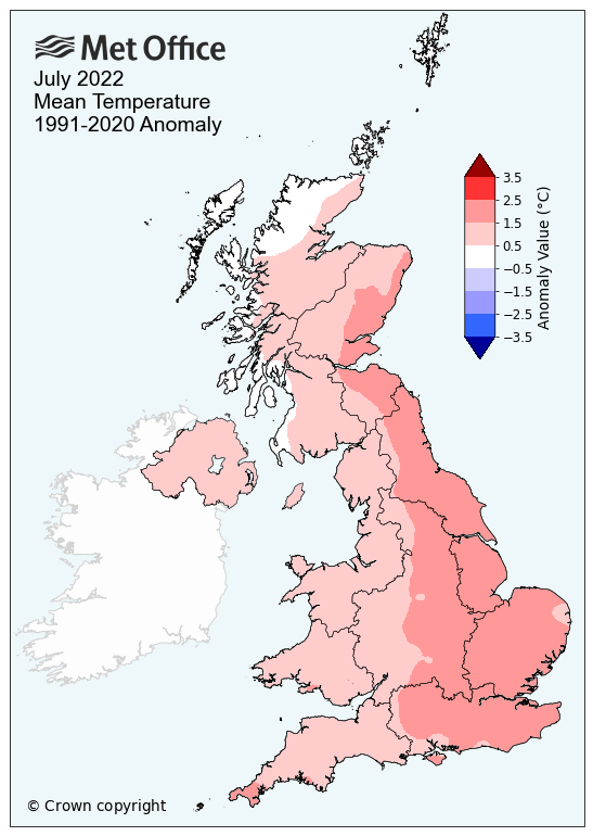
While being a dry month, July 2022 went down in UK climate history as the first time the UK exceeded temperatures of 40°C on 19 July, during an intense heatwave where the UK saw its new record high temperature of 40.3°C at Coningsby, Lincolnshire. Wales also recorded its highest temperature with 37.1°C at Hawarden, and Scotland followed suit with a record high figure of 34.8°C at Charterhall.
That record-breaking heatwave wasn’t the only heat reported in the month, with notably warm periods either side of the unprecedented heatwave, resulting in average maximum temperatures for July sitting in the top ten for England, with 23.5°C the average maximum temperature, some 2.3°C higher than average.
Warm days were coupled with warm nights, with northern England provisionally setting a new average daily minimum temperature record for the month, with 12.5°C, which is 1.3°C above its average.
As a result, mean temperatures for the UK were well above average, standing at 16.6°C, which is 1.3°C above average and the joint-fifth warmest July in a series which dates back to 1884.
With seven months of the year’s statistics now having being reported, mean temperatures have been higher than average for every month so far this year, with the average mean temperature at 9.7°C making the first seven months of this year the second warmest on record after 2014. However, the first half of the year does not dictate the second half of the year and so it is too early to say how these statistics will compare by December.
Mark McCarthy, Head of the National Climate Information Centre said: “The extreme heat in the middle of July was headline-grabbing, but the heat was fairly widely above average for much of the month, with the southeast especially warm.
“Persistent high pressure, coupled with warm air being drawn in from the continent at times, has led to settled conditions for much of the UK and temperatures well in excess of averages at times.”
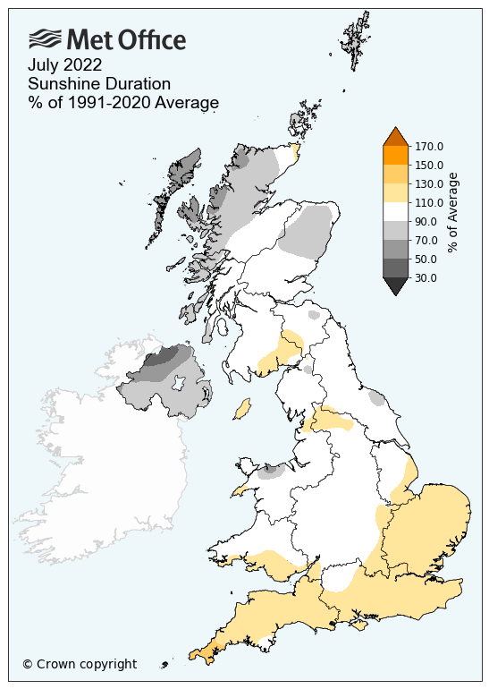
The UK saw 179.4 hours on sunshine on average throughout July, which is just over the national monthly average. As well as being the warmest and the driest, southern counties were the sunniest too with some regions recording in excess of 280 hours, and for East Sussex the 8th sunniest July on record. For Northern Ireland, it was the eighth dullest July on record, with 95.7 hours of sunshine, which is 30% fewer hours than average.
| Maximum temp | Minimum temp | Mean temp | Rainfall | Sunshine | ||||||
|---|---|---|---|---|---|---|---|---|---|---|
| Area | Actual temp (°C) | Anomaly (°c) | Actual temp (°C) | Anomaly (°C) | Actual temp (°C) | Anomaly (°C) | Actual (mm) | Anomaly (%) | Actual (hours) | Anomaly (%) |
| UK | 21.3 | 1.7 | 11.8 | 0.8 | 16.6 | 1.3 | 46.3 | 56 | 179.4 | 103 |
| England | 23.5 | 2.3 | 12.7 | 0.9 | 18.1 | 1.6 | 23.1 | 35 | 217.3 | 111 |
| Wales | 21.1 | 1.8 | 11.7 | 0.4 | 16.3 | 1.1 | 52 | 53 | 184 | 104 |
| Scotland | 18.2 | 0.9 | 10.5 | 0.8 | 14.3 | 0.9 | 83.6 | 81 | 129.1 | 92 |
| N. Ireland | 19.4 | 0.8 | 11.7 | 1 | 15.5 | 0.9 | 45.8 | 51 | 95.7 | 70 |